Smart Automation in Roadbuilding: More precise asphalt reclamation and paving – connected, automated and fully integrated
Smart Automation in Roadbuilding stands for precise asphalt reclamation and paving along paths defined by digital terrain models. The data is made available via an open interface, automatically checked for practicability,
Plannable results in higher quality and with fewer resources at the press of a button
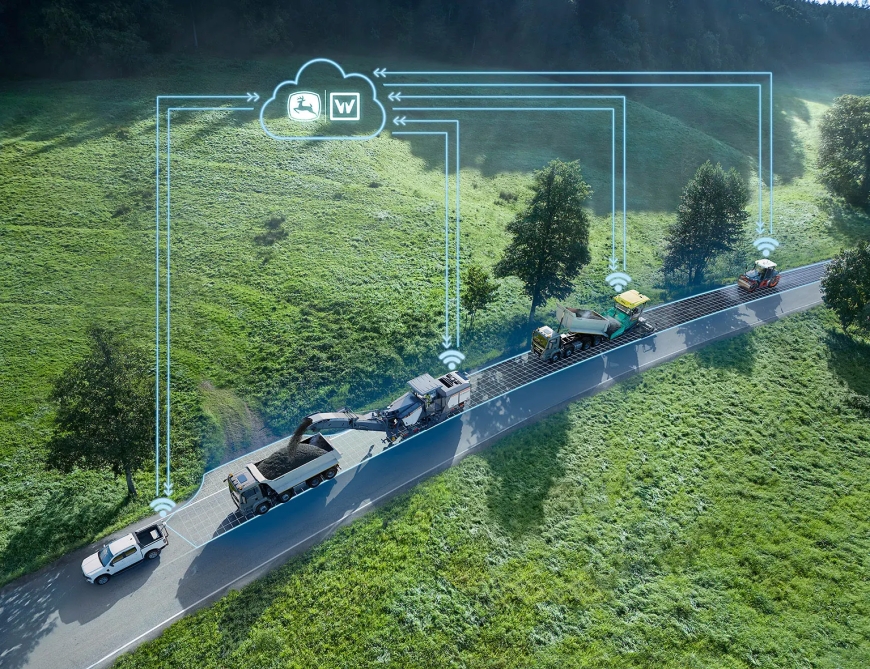
Smart Automation in Roadbuilding stands for precise asphalt reclamation and paving along paths defined by digital terrain models. The data is made available via an open interface, automatically checked for practicability, transferred to the machines via wireless communication and then used for controlling the milling depth and screed position. Full integration in the machines leads to predictable results, higher precision, better quality and lower material consumption in asphalt construction.
The Wirtgen Group solution Smart Automation in Roadbuilding has been nominated for the bauma Innovation Award 2025 in the category ‘Digitalisation’.
Digital terrain models used for controlling machines are characterized by accuracy, predictability and precise compliance with target values. They simultaneously present a number of challenges in practice: Additional outlay for the registration and provision of data, planning, and skilled personnel for operating machines with 2D/3D machine control systems and for the installation of surveying/measuring equipment on the construction site. At the same time, the low data transparency leads to reservations on the part of machine operators when faced with complex technologies.
All from a single source: Work Planner, Smart LEVEL PRO and Smart Pave
With Smart Automation in Roadbuilding, the Wirtgen Group provides new digitalisation and automation solutions for asphalt rehabilitation that enables easier utilisation of the advantages of digital terrain models and the solution of challenges in practice. The key components are the Work Planner as a digital tool in the John Deere Operations CenterTM, Smart LEVEL PRO for automation of the milling depth and cross slope on Wirtgen F-series large milling machines and Smart Pave for automatic control of the screed position – i.e. steering and screed width adjustment – in the case of the Vögele Dash 5 compact class tracked pavers.
Milling process: Improvement of evenness
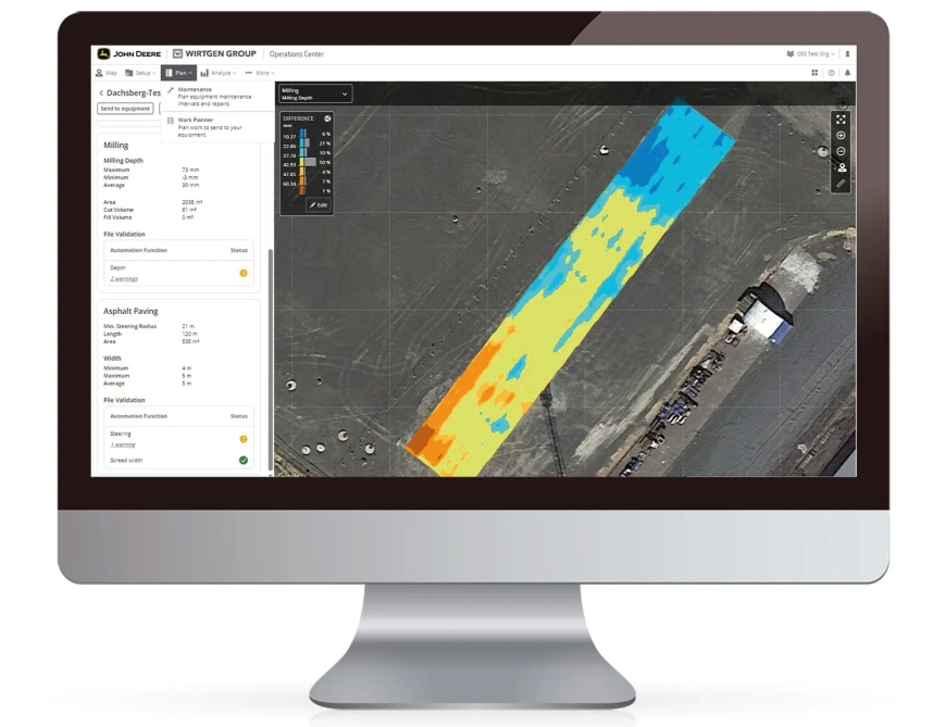
Planning data that can be generated by all commonly used surveying and planning software solutions are made available in the Work Planner via an open interface. A model of the existing area and a model of the area to be milled are required for the automatic control of the milling machines. The Work Planner analyses and checks whether the data is usable for the automation process. Parameters such as the milling area, milling volume and minimum, maximum and average milling depths are displayed directly on the screen. The distribution of the different milling depths in the course of the project is also visualised.
Asphalt paving: Compliance with considerably tighter tolerances
For automated asphalt paving, three lines defining the steering line and the two outer edges of the project area are provided to the Vögele pavers. This enables the realisation of considerably tighter tolerances in the paving process. The Work Planner shows users a clear overview of the area, length and orientation of the paving project.
A map-view option enables personnel without a background in surveying to easily localise and check the project. Site managers, surveyors and resource planners benefit from the transparency of the data, their practicability and the expected final result prior to the start of the paving project.
Connectivity increases operational efficiency
For the realisation of a project, the data can be shared with other contractors or transmitted to freely selectable machines from the operator’s own connected fleet via cellular communication. The machine control systems are already fully integrated in both road pavers and cold milling machines and require no installation of additional components. Localisation of the machines with the necessary accuracy is enabled by a GNSS receiver with an RTK correction signal.
Easy operating
The operating concept couldn’t be simpler: All the machine operator has to do is choose the desired control mode on the familiar control screen. Thanks to the Live-View of all relevant project data, the operator always knows which mode the machine is in and what actions and control commands can be expected. The automated processes considerably reduces the crew’s workload and leads to a measurable increase in the precision and quality of the final results. A further advantage: Fewer surveying resources are required on-site in comparison to 3D and retrofit solutions.
Fewer resources, better quality, and increased profitability
Smart Automation in Roadbuilding, the new digitalisation and automation solution from the Wirtgen Group, enables the realisation of precise and cost-efficient paving results in compliance with planned targets with the core construction crew and without the need for additional, specialised personnel. Factors such as costing analyses in advance also enable optimisation of the material volumes and logistics required for the realisation of the project. All in all, road construction contractors enjoy the benefits of increased planning reliability and predictability of the final results.
The Wirtgen Group solution Smart Automation in Roadbuilding has been nominated for the bauma Innovation Award 2025 in the category ‘Digitalisation’.
The Wirtgen Group Solution Smart Automation in Roadbuilding enables predictable realisation of final results in asphalt construction with higher quality, fewer resources and greater profitability.
A core component of the Wirtgen Group Smart Automation in Roadbuilding solution is the Work Planner: As a digital tool in the John Deere Operations CenterTM, it analyses and checks whether the data from digital terrain models are usable for the automation process.